This is an ongoing investigation, almost 90 years old… UPDATED November 25 2023.
I can’t remember exactly when I first read about the carved stone head found at D’Arcy, Saskatchewan, but I think it might have been Facebook. Before the pandemic, sometime in the twenty teens…
And the remembered image has haunted me. It would pop up now and then in my imagination: where did that stone come from, and where is it now?
This fall, I began to dig. Why? Great question. I’m so glad you asked. I don’t really know, except: as I said, it haunted me. It would pop up randomly in my mind. I always thought, someday, I’d love to see it.
This summer, I’ve been actively chasing buffalo rubbing stones, which has led to tipi rings and cairns and effigies, then to stone effigies and every kind of archaeology. So now my imagination circles here again. Whenever I heard a story of someone finding an arrowhead or spearpoint or hammer head or something even cooler, like a petroglyph stone, I would think: Remember that cool, weird stone head? I wonder where it came from? And… where is it?
Here’s where the whole thing started, and I’m pretty sure this is what was shared on Facebook, and triggered my imagination.

published in American Antiquity, 1940

When I was out with the archaeologists at the Hoppe farm in October, I asked if they remembered the stone. One said, yes, I think it’s in the museum in Kindersley.
Kindersley? Well that’s not that far. About an hour and a half drive. My practical brain said, You should check first. So I did. I sent an email: do you have that stone found at D’Arcy? The reply was swift. Yes we do! Call ahead and drop by!
So I did. Friday, November 10th.
And I’m telling you, it’s absolutely fabulous.
The museum can be found on the eastern outskirts of Kindersley, in a building that you’d mistake for an agricultural machinery dealership. But the caretaker is friendly and knowledgeable, and it’s well worth your time to stop.
The stone is not in the main part of the museum, which is a classic rural museum, chock a block with everything from Eaton’s catalogues to sad irons to roller skates.
To the left of the front door is the ‘archaeology room.’ Inside, you’ll find glass display cases filled with treasures.
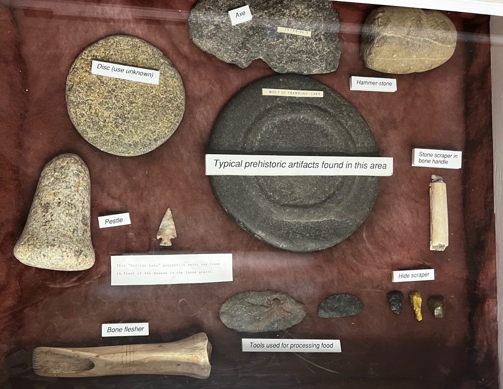


On the wall right when you walk in the door, pride of place, there is a half-moon case with plexiglass. Bolted to the wall, in farmer-worthy sturdiness, is the case with the D’Arcy stone head.

Found in a gravel pit south of the village of D’Arcy, Saskatchewan in 1934 by farmer Wesley St. John, the stone has has quite the history in Saskatchewan — and I’m just starting to uncover that story.
The stone was about five feet down , on the edge of the gravel pit. The entire region is known for its quality gravel. Even now, in 2023, the area is full of pits and piles. The gravel pit was on the edge of a coulee leading down to Bad Lake, in the Bad Hills region of the province.
North of D’Arcy lies the little village of Herschel, Saskatchewan. At Herschel are ancient petroglyphs, a turtle effigy, a bison jump site, and other even more ancient finds: plesiosaur bones.
The Bad Hills were a meeting place for the Cree and the Blackfoot. The site at Herschel contains both Cree and Blackfoot cultural artifacts, indications that the site served as somewhat neutral ground — a cultural space to which both would congregate.
It’s not beyond the realm of imagination that Herschel, and other places within the Bad Hills such as Cabri Lake south of Kindersley, and Bad Lake south of D’Arcy, were sites where many cultures could met.
Wesley St. John took his find home. It was an unusual find, but perhaps not entirely so. Saskatchewan archaeology spiked during the 1930s with the drought desiccating the land, exposing hundreds of finds across the province.
There were also numerous local civil engineering projects on the go, including roads, culverts, and bridges. Municipalities found that local farmers would offer to work as a way to pay off taxes owing, an arrangement which suited many. Improving roads became more and more important as horse and wagon gave way to cars.
There was not an archaeology department at the university at the time, and the museum at Regina didn’t seem to be involved at that point in the stone’s Saskatchewan adventure. There were few to turn to for expert advice or knowledge.
The local station agent at Eston, one Fred James, took it home to study, but the studies didn’t seem to provide any answers. He had it in his basement alongside the rest of his archaeological collection until Wes St. John took it back home.

St. John primarily kept the stone head where he would see it every day: it was the doorstop for his back door.
[Addition Nov 25: from Facebook after the story was originally posted and shared:]


A young teacher by the name of Ruth Smith came to teach at McCarthy school. She boarded with Haydee and Wes St. John in January, 1935.
She saw the stone and was, of course, intrigued.
Her beau, Phil Puxley, was studying Chemistry at the University of Saskatchewan. One of his professors, Valdimar Vigfusson, was a specialist in petrology (studying the chemistry of stones).
Valdimar Vigfusson was a USask professor who has been almost lost to history. I found no mention of him in any of the published histories of the universities, though he [should] have his name on one of the Great War scrolls in Peter McKinnon building.
Vigfusson was born at Tantallon, Saskatchewan (near Yorkton) in April 1895. He graduated with a chemistry degree from USask in 1917 and joined the war effort, first in the army, then in 1918 switched to the air force.
After the war, he worked for both the Salt and Chemical Society of Saskatchewan, and as a chemical analyst with the Government of Saskatchewan. He defended his Masters in 1925, and achieved his PhD from the University of Wisconsin in 1930. He joined the Department of Chemistry at USask in 1931. In his short 10 year career, he became a Fellow of the Chemical Institute of Canada, and a member of the Canadian Chemical Society.
But it’s Vigfusson’s side interest in Saskatchewan Indigenous artifacts and archaeology that would raise his profile across Saskatchewan. The chemistry professor would travel the province, seeking out stories and artifacts found in farmer’s fields or held by First Nations. He would also collect dinosaur bones and is rumoured to even have had a dinosaur egg in his large collection.
He shared interest in the past with well-known Saskatchewan historian A.S. Morton. Morton traveled the length and breadth of the province searching for early western Canadiana history and hunting down fur trade fort sites. Vigfusson was a regular partner in these escapades.
When workmen near Bradwell were digging in a gravel pit for road construction material in 1936, they uncovered and disturbed an ancient grave site. They called the police, who called Dr. Vigfusson. That was the power of his reputation — even though archaeology was just his vocation and not his training.
What he brought, though, was a scientist’s precision to the study of the physical past. He believed in systematically documenting finds, and became known for his methods. He enthusiastically worked to create the Saskatoon Archaeological Society, and even had an archaeological dig at Beaver Creek named after him.
When Ruth told Phil Puxley about the strange stone holding back the door in the St. John home, Phil told his chemistry professor, Dr. Vigfusson. The two made a trip in Vigfusson’s car — a rarity in the depths of the Great Depression — out to the D’Arcy area.
Vigfusson was enthralled. Everything about his research work, both petrology and avocational archaeology, was combined in this one stone. Wes St. Denis took them out to the gravel pit to have a good look around in case other artifacts were visible or there were any indications that could be useful. They were disappointed.
Nonetheless, the chemist took detailed notes of the land location, terrain, presence of alkali and drinking water nearby, and noted stones that were clearly used in tipi rings. It was, in his view, clearly a find directly related to the region, and its Indigenous past.

Undaunted, the professor knew one thing: he wanted the stone. He wanted to take it back to Saskatoon for his collection, and possibly even to run some tests in his lab. He offered Wes St. John $10 for the stone head, and the farmer thought it was a fair exchange.
So the stone went with Puxley and Vigfusson to Saskatoon.
Vigfusson documented the find and the stone in 2 pages of keen detail for the ‘Facts and Comments’ section of the leading research journal American Antiquity in April, 1940.
It’s not known if Vigfusson did chemical analysis on the stone, except to determine the kind of stone used. The stone is sandstone, striated pink and grey, ‘visible when wet,’ which showed that he wasn’t afraid to handle the artifact and put it through some analysis. It’s not similar to any known glacial drift from the nearby prairies or plains. Clearly, it is thought to have been carried here from somewhere else, and most likely, was carved elsewhere before coming to rest on the hills above Bad Lake.

It’s clear that the stone is carved, and though Vigfusson thought that a flint or quartzite chisel was used, later archaeologists believe that the stone was carved with steel tools. He measured and calculated and reported on the size and shape of the artifact and the carving techniques of grooving and cutting to create relief, then rubbing and polishing.
The carver, he said, showed both ingenuity and artistry, and reminded him of artwork from the Pacific Coast or down into Mexico or Mesoamerica, including potentially Mayan in origin, with some similarities.
To solicit opinions, Vigfusson took beautiful clear photos of the stone which were included in the article as the middle page. “The opinion of archaeologists familiar with the art of these areas would be welcomed.” It is not known if Vigfusson received any learned opinions via letters.
Nonetheless, the stone being found in Saskatchewan was a clear indication of movement and migration, for trade and commerce or to pursue climate and geographical opportunities. At the time, archaeology was pursuing the Bering Land Bridge theory, and Vigfusson wondered if this stone might be a clue.

Vigfusson remained close with Phil Puxley and Ruth Smith, even serving as a last-minute stand-in best man at their wedding. He continued his chemistry research with Dr. Thorberger Thorvaldson of the university, investigating the properties of Portland cement, and spent evenings and weekends immersed in history and archaeology.
Then tragedy struck. Coming home from a hockey game in Saskatoon in December 1942, in a car driven by his friend Lyle Johnson of Outlook, the car skidded on the ice of the 25th Street Bridge. They weren’t going fast. It wasn’t even a bad skid. But the car struck a pole on the passenger side and Vigfusson hit his head.
The accident was just forceful enough, and the way the pole hit the car, and the angle, meant that his skull cracked on impact. He died later that evening in hospital.
When a university professor dies today, there are processes in place for the department, college, and university to follow. In 1942, those processes were not well established. Vigfusson was unmarried, with no children. His father and brother still lived in Tantallon, and that’s where he was buried.
But his collection, built over many years through the depths of the 1930s and the start of the Saskatoon Archaeological Society, left his chemistry colleagues scratching their heads. What were they to do with all the stuff?
And the carving… where was it? It was thought to have been on display in a downtown Saskatoon store at the time of Vig’s death.

Displays were a common practice. Stores would often offer their display area for local ‘oddities and interest’. In Rosetown, Valley Centre farmer Albert Kessel did a fall display of all the fruits and vegetables grown on his farm, as exotic as apricots and Manchurian walnuts. Curler and later Saskatchewan Lieutenant Governor Sylvia Fedoruk had a huge collection of curling pins, which were put on display for a time in a downtown Saskatoon store.
After Vig’s death, the store returned the D’Arcy stone to the university, and another professor — no one is quite sure whom — kept it, either in their office or took it home. At some point, it was in a private home which was sold. The new owners didn’t like the stone and so threw it away — into a back alley somewhere in Saskatoon.
That’s when a University of Saskatchewan student, possibly taking archaeology classes, found it while out on a walk. They returned it to the university, this time to the archaeology department which was formed in the early 1960s with Zenon Pohorecky as head.
From there, the stone bounced around. It’s thought to have gone to the provincial museum in Regina during the 1960s and 1970s, when a copy of the stone was made. [Note: the above tracking of what happened to the stone is what the letters and reports held in the Kindersley Museum explained. However, read below for new and slightly different information.]
[ADDITION: Thanks to records kept at the Royal Saskatchewan Museum, which they kindly scanned and shared with me, we know a bit more about what happened. In 1972, the bowl resurfaced, and a series of letters explain what happened.]
Valdimar Vigfusson’s extensive collection had been catalogued after his death by Joyce Crooks of the Saskatoon Archaeological Society. “During the cataloguing process she and others noted the absence of a particularly interesting stone bowl which Vigfusson had purchased sometime back in the thirties.” They scoured the university, checking everywhere for it, but it was to no avail.
But in 1972, the bowl had been found in a private collection in Moose Jaw. Margaret Hanna of the Department of Anthropology at the University of Manitoba would go out scouting through private collections, and saw what she thought would likely be the stone. At about the same time, Gil Watson of the Archaeology Division of the Museum of Natural History in Regina explained: “When I was in Saskatoon for the Rock Art Conference, I spoke with Mrs. Cauldwell and Ernie Hedger.” Apparently, they also knew about the stone bowl and gave Watson the address in Moose Jaw.
The private collection, which included the D’Arcy stone head, belonged to Leonard and Francis Bruvold. The Bruvolds had married in Choiceland in 1928. They left the forest fringe and resided for many years in Saskatoon before relocating to Moose Jaw. Francis Bruvold told Margaret Hanna that a friend had given Leonard the stone head, likely during their time in Saskatoon.
Joyce Crooks heard that the stone head has possibly been located, and quickly sent a letter to James F. V. Miller, head of Archaeology at USask. She suggested to Jim Miller, “possibly you could get a look at it.” She added, “I’m wondering if it’s the real one or the replica Vig’s students made up as a joke. Had you heard about that? Well Dr. Miller, I do hope we have unearthed the real thing at long last.”
Miller immediately wrote to Mr. Gil Watson in Regina. Joyce Crooks had heard that Watson had the bowl in Regina, to make a cast copy. Miller asked Watson to hold onto the bowl, and to contact the Bruvolds, to let them know that the bowl had been possibly stolen or at the very least, misplaced. The underlying suggestion in the tone was that the stone bowl didn’t necessarily belong to them.
Gil Watson wrote back immediately with news. Watson went to visit the Bruvolds and told them as much of its history as he knew. “She then loaned it to me for casting.”
Watson had suggested to Mrs. Bruvold that the university would appreciate the return of the bowl. She was more than willing, but Mr. Bruvold wished to keep it. Watson added to his letter to J.V. Miller, “I think when they bring it to the university you could explain again the scientific value and perhaps he will be more cooperative.”
At the bottom of the letter, he added: “P.S. The bowl is the one in question and is not as far as I can tell a duplicate or a fake.”
Possibly the most interesting note in the files from the Royal Saskatchewan Museum is the hand-written note from Mrs. Bruvold to Gil Watson. “Would you let me know by letter when you have finished copying the Indian lamp. We will call for it ourselves as I have to come to Regina soon.” A note from Gil Watson on the bottom of that letter reads: “Stone face returned in person March 28/72.”
Then, another coincidence. Lester Smith (brother to Ruth Smith, the teacher) ran a photography shop in Saskatoon. He’d also wondered what happened to the stone. One day, a USask archaeology student came in with glass negatives that the department wanted processed. To Les’ surprise, the pictures were Dr. Vigfusson’s originals of the D’Arcy stone. [Note: these photographic glass negatives had been found and prints made by the Archaeology department just prior to 1972. Copies were included in the letter sent to Gil Watson from J.V. Miller.]
The stone itself was returned, not to the archaeology department, but to the home of Dr. Miller, who was head of the department in the 1970s. [Yes. The Bruvolds were clearly persuaded to return the bowl, and it went not to the University but to Dr. Miller.] Lester Smith saw the stone when he was there on a different errand.
By this time, archaeological interest and investigation of the stone had waned. Those who studied the stone decided that it had been made by steel carving tools – though they admitted that does not account for it being still quite old, and why it was found at D’Arcy.
E.A. Johnson of Kindersley thought that the stone had been planed before carving, a rather modern technique, though there have been stonemasons using tremendous techniques for stone building for thousands of years. He also thought that there might have been at least four different steel carving chisels used on the stone, which again, does not preclude the stone being much older than western Canadian farming settlement.

Ian Brace, curator of archaeology in Regina, thought that the stone couldn’t be particularly old, as its edges were not abraded, but rather sharp. It’s not been exposed much to weather, either — but then again, it was found in a gravel pit and has been kept inside and dry for its life in Saskatchewan, with the exception of being thrown into an alley.
Nonetheless, the stone continued to arouse interest and thought. Ruth’s daughter, in the foreign service, saw carvings in a northern city in Siberia that reminded her of the stone head. Likewise, Beatrice Medicine, an anthropologist from South Dakota, is also recorded as suggesting that there could be some Russian influence in the carving. These observations would certainly have been welcomed by Dr. Vigfusson, who was of the opinion that the stone could prove to be a link to the Bering Land Bridge idea — or at least, of travel from far away.
In the late 1980s, Dr. Miller turned the stone head over to the Saskatchewan Archaeological Society, who retains ownership of the odd artifact. It was granted on extended loan to the Kindersley and District Plains Museum — and that’s where you can go see it.
For me, the finding of the stone and ‘what happened after’ is as much to my interest as a historian as the stone itself, though the stone head still looms large in my thoughts and imagination. I’m working with the USask archive to see what we can turn up about Vigfusson. Cheryl Avery has records that indicate that the entire collection may have been subsumed into the University’s museum collection, but that’s the next avenue of investigation. I’ll also be reaching out to the provincial museum, and to the USask Archaeology department, to see what their files might reveal. [See above for the additions from the files of the Royal Saskatchewan Museum. The Archaeology Department had nothing more to add, but I’m hoping for more news from the Saskatoon Archaeological Society.]
As Ruth Puxley said, I don’t believe it’s a fake. Wes St. John, despite being a prankster, never gave any indication that this find was anything but a uniquely interesting artifact found in a gravel pit on a hillside south of D’Arcy, near the west shore of Bad Lake. And if it was a prank then, who was the prank for?
The mystery of the D’Arcy stone head remains.


 So, the first thing that I do is define the soft borders around my research region, as a way to contain and focus my research question. What this does: it helps me focus my archival and library and oral interview work. I specifically search for books, theses, articles, and archival documents written about my research region and seek out a variety of specialists and knowledge-holders to read, study, and interview. I also visit, usually many times. The search is a large and usually an on-going process. It’s never finished; you can never find everything, see everything, know everything. A place historian must embrace a little bit of ambiguity, of vagueness at the edge of the laser focus.


 So, the second step in place history: create a landscape timeline. This timeline will help you draw clear connections between the landscape and the human activities you record as significant aspects of your research question. It can also help you choose more clearly which human decisions – politics, policy, or development – you need to understand in order to engage with your landscape. The answers to that can be unexpected.
 Why does a place historian need so many sources? Because each has a significant contribution, and each has the potential to carry a part of the story independent of other knowledge-holders. The story of the avulsion is a good example: its story is carried in the historical record and in the research projects of delta scientists. Yet it was virtually eclipsed from the Indigenous local memory. You cannot rely on one source to the exclusion of others. In a place history, you’re building a landscape timeline of a place, deliberately blending multiple viewpoints and information so that nothing is in isolation. A place history can show how a local lumber industry melded with local agriculture, First Nations, and the environment, with influence and impact in many directions.
 In 2013, when flood once again threatened, the community was forcibly evacuated by the provincial government who clearly did not understand either the depth of flood memory, the elders’ knowledge, nor community resilience. It was, as in 2005 and 2011, a needless evacuation. The community did not flood. The provincial safety manager told me later, in confidence, that they would never again evacuate Cumberland House. Flood measures and protections, when used well, would be enough. Finally, the provincial emergency management leadership learned what local Indigenous elders drawing on a deep-time knowledge of water and the delta knew: the delta absorbs and spreads the water over a massive landscape; it floods, but it does not flood.
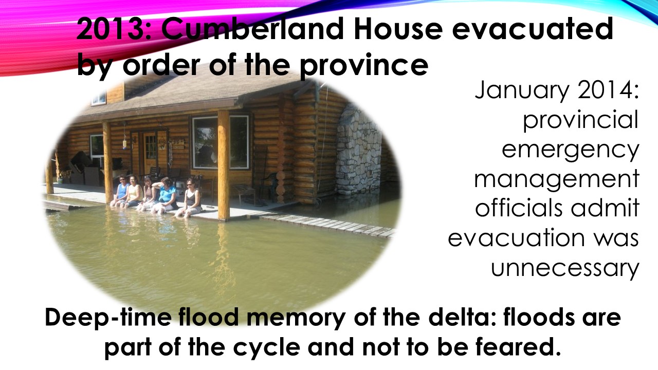
 Why is place history important? It is a methodology that allows us to ‘see’ and compare issues across time, through the eyes of a particular place. Place methodology offers a deep time perspective that transcends dramatic events to consider the broader implications of the intimate connection between humans and the environment: the delta as a water landscape, and how we’ve moved with, against, challenged and changed that; the forest edge as a rich ecotone between the prairie and the forest, and how we’ve moved that edge back and forth through axe and fire, agriculture, and tourism. What I find doing place history is often unexpected, and sometimes challenging to the status quo, because I’m starting from a different vantage point: the landscape, rather than the people.


