Place: A Methodology for Research
By Merle Massie, PhD.
Conference paper presented at World Congress in Environmental History. Guimaraes, Portugal, 2014. Edited for blog post August 2017.
In June of 2014, I was in my hometown of Paddockwood, Saskatchewan, Canada – population less than two hundred in the village, less than a thousand in the rural area. I was there to give a talk and show a slideshow of pictures from my most recent book, Forest Prairie Edge: Place History in Saskatchewan. It’s a place history of the region, which I spent four years researching and writing. As the lights darkened, a hush fell – with obedient silence – over the crowd. Kids squirmed, adults settled in, and my Great Aunt Clara folded her arms and leaned back. She listened with one eye half-closed as I moved from picture to picture, from story to story. She likes to make sure that I tell the stories right, that what I say agrees with her memories.
Locals can be a tough audience when you write a local history, but the slideshow and stories were a big hit. Clara got a chance to add to one or two of the stories, providing a few details on the local cheese factory, but I scored a home run: I told her some stories that she’s never heard before. She was introduced in a new way, to the place that she knows best.
And there’s that word: place.
Place is ubiquitous; it is everywhere at once. From ecology to history, place is a word that is used often in the English language: someplace, no place, every place, any place. First place. Second place. Last place. Place that over here. You’re sitting in my place. Let’s go to my place for a drink.
Place is a popular focal point for study. Geographer Yi-Fu Tuan eloquently said that space plus culture equals place (1977). There are reams of literature studying sense of place, place attachment, place dependence, place remaking, non place (or, the internet, which is everywhere and nowhere). The omnipresence of the word ‘place’, has led to controversy and discussion, multiple theoretical threads and calls in both directions: use it more broadly; and don’t use it at all.
I do use place. I use it to describe what it is that I do, which I call ‘place history’. This blog post, which was first presented at the World Congress in Environmental History in Portugal in 2014, is a rough attempt to explain place not as theory, but as methodology. Warning: I’m rather allergic to theory, and decided this post is no place for a literature review, or even much in the way of references. If you’re looking for them, sorry. I’m posting this presentation because of these tweets:

Place based inquiry tweets
So, with apologies to Kaitlin Stack-Whitney who might be looking for a lit review or recommendations, this isn’t that. I’m going to describe what I do, when I set about to do a place-based inquiry.
I use ‘place’ as a method of organizing my research, of building a different kind of story. How many of you have read Dan Flores’ suggestion that we use a bioregion as the focal point for environmental studies? (I love that article. Go read it). My work follows on Flores’ in that I’m interested in the environment as a central defining part of place history. This post will explain three short-ish points about how I do it, and what kinds of information place history can show. The examples are drawn from two different research projects I’ve created in the last few years (with images from the powerpoint presentation).
So: what is place history? Place history is a research strategy. It is a way of organizing and focusing your research. At its core, it studies a particular place through the lens of time. You start, like we all do, with a research question. For my hometown place history, my research question was: what has my hometown region looked like in the past, and how has it changed over time? For the second research project, the question was, how has this landscape, and its people, responded to floods? As you can see, the first question was a bit larger, while the second focused specifically on a particular kind of event (flood). Both had advantages and drawbacks.
I start a place history by first defining a soft border around a research region. Sometimes, there is a natural boundary line that I can follow, but sometimes not. My hometown story is not a bioregion, in that it doesn’t have specific biophysical markers. It sits, in fact, at the transition zone between two bioregions, and that’s part of what made it interesting for me. It sits where the North American interior plains hit the northern boreal forest in my home province of Saskatchewan. Saskatchewan in known as the ‘land of living skies’, a prairie space, flat and treeless. I once heard my research summed up in three words: Saskatchewan has trees. I thought, good enough!

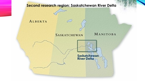
The second study involved a massive inland delta, a water landscape covering 10,000 square kilometers – about one-tenth the size of Portugal. The Saskatchewan River Delta is a primarily Indigenous landscape of enormous importance, ecologically, economically, and socially in the interior of Canada, straddling the border between Saskatchewan and Manitoba. Most of my work focused specifically on the upper delta, centering on the community of Cumberland House and the delta that surrounds it. The biophysical marker makes the research region easier to identify, but studying water means studying all the places the water was before it gets to the delta, so again, ‘soft’ boundaries are important.
 So, the first thing that I do is define the soft borders around my research region, as a way to contain and focus my research question. What this does: it helps me focus my archival and library and oral interview work. I specifically search for books, theses, articles, and archival documents written about my research region and seek out a variety of specialists and knowledge-holders to read, study, and interview. I also visit, usually many times. The search is a large and usually an on-going process. It’s never finished; you can never find everything, see everything, know everything. A place historian must embrace a little bit of ambiguity, of vagueness at the edge of the laser focus.
TWO: the second part of my place history research methodology involves time. Place is about landscape; history is about time. As I find information about the place I am studying, I create a landscape timeline. I won’t show you one, because they tend to be messy, but do it however you want: on a whiteboard, using post-it notes on a poster board, using Excel or another program, or in a memo book. The point is to remember and celebrate that the landscape is not just the ecological backdrop for the human story. The environment is neither static nor inert. When you write a place history, you are telling the story of the land; people’s activities are a response to that land, and the land responds back. When I work on place history, the landscape becomes a key and active player in the story, an actor whose decisions have implications across the landscape and across its human inhabitants.
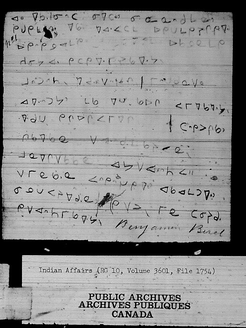
Let me give you an example: in the 1870s, less than 150 years ago, the Saskatchewan River – the river which creates the Saskatchewan River Delta – experienced an avulsion. An avulsion means the river jumped its track, leaping out of its riverbed to blow out a whole new river pattern, completely changing the way the delta works and how and when and where people could move through it. Steamboat traffic changed. Trapping patterns and fishing patterns changed. Silt rose, to the point where dredging was necessary to keep the boats running and people were predicting that Cumberland Lake in the centre of the delta would, in time, silt right up and become farmland. The effects of that avulsion are still working through the delta. But the avulsion had little to no imprint on the memories of the local Indigenous population, at least until scientists recovered it and started talking about it in the community. The avulsion can be traced through the historical record and scientific investigation, but little in the local memory. The avulsion’s fingerprints remain on the land, and it became my job to find out why those fingerprints were largely missing from the oral story.

The key part of writing a place history is to remember that neither the land nor the people are static. A landscape timeline gives me recreated snapshots or descriptions of what the landscape looked like at a particular time, and how humans used the landscape, and how and when and why things changed. With a landscape timeline, I can ‘layer’ both environmental change and human change to see what affected what, and with what consequences.
In the case of the delta, I soon found that the massive changes caused by the avulsion had disappeared from the local story because they’d been superceded by even more massive change in the twentieth century, much more recent in the memories of the local population. A dam, upstream from the delta, had dammed the water to create a large lake and hydropower supply. This dam, and the way it was run, disrupted natural rhythms to such an enormous extent that the local story started to sound black and white: before the dam, after the dam. The avulsion as an integral landscape story virtually disappeared. I only learned about it because, as a place historian, I was diligently collecting information across time, building my landscape timeline.

What I’ve discovered is that, by shifting the focus from a human-centered to a place-centered timeline, I have a clear perspective on what activities are possible, probable, or practical in a certain place in a certain time. It also helps serve as a predictor: what can make this landscape seem more desirable, or less desirable, as a place of human habitation? In the work I did on my hometown region, it became clear to me that the local landscape became desirable, and as a consequence became a major destination for climate refugees, during the global environmental and economic disaster of the 1930s. Whereas the nearby landscape, the Great Plains of North America, suffered severe ecological drought, the forest edge still had water in wells and coming down from the sky, trees for shelter and fuel and building materials, hay for starving animals chewing dust, gardens where “even the turnips were edible,” wild game and berries and fish. In short, there was a comparative natural abundance to feed animals and humans. It became desirable because it didn’t have endless black blizzards. As a result, almost 50,000 people relocated from the dust bowl to the forest fringe of my home province, a massive internal migration that changed the face of land settlement, agriculture, and population.

 So, the second step in place history: create a landscape timeline. This timeline will help you draw clear connections between the landscape and the human activities you record as significant aspects of your research question. It can also help you choose more clearly which human decisions – politics, policy, or development – you need to understand in order to engage with your landscape. The answers to that can be unexpected.
The downside is that as your landscape changes over time, and as human activity changes over time, you as the researcher will need to become a jack of all trades. You’re not just an expert in one event or one theme or one theory; you’ve got to learn something about everything. This puts you at a disadvantage when speaking with an expert dedicated to one group, one policy, one moment, but remember that your perspective is built with light from many sources. And that can, and does, bring forth fresh new perspectives.
This multiplicity brings us to the third and last point: place history methodology draws knowledge from across a range of knowledge holders and creators. This range is substantive: science, social science, humanities, Indigenous knowledge, and the natural world. Data (I’m sorry – I hate the word ‘data’ but I use it because people understand it) data from natural and social science is deliberately blended with professional history, oral and community history, literature, and art to provide a broadly-based comparative framework. This is natural and physical science plus social science and humanities.
 Why does a place historian need so many sources? Because each has a significant contribution, and each has the potential to carry a part of the story independent of other knowledge-holders. The story of the avulsion is a good example: its story is carried in the historical record and in the research projects of delta scientists. Yet it was virtually eclipsed from the Indigenous local memory. You cannot rely on one source to the exclusion of others. In a place history, you’re building a landscape timeline of a place, deliberately blending multiple viewpoints and information so that nothing is in isolation. A place history can show how a local lumber industry melded with local agriculture, First Nations, and the environment, with influence and impact in many directions.
Another example. The Saskatchewan River delta is historically a flood landscape, with thousands of years of flood adaptation and flood memory. Using place history methodology, I focused on my research region and looked for information across time, regarding flood events. In 1781, a major spring flood blew out the newcomer European traders, drenching their valued goods and creating a quagmire out of their fortified trading post. The Indigenous inhabitants simply moved to drier ground. The flood was a seasonal event; perhaps higher than other years, but not enough to shift anything in the Indigenous daily life, yet making a mockery of the newcomers.
Turn the clock forward to 1962, when the EB Campbell Dam was built, upriver from the delta. Floods changed. High water events came at different seasons. Rushing water came suddenly, at different times of the day, blowing out traplines and fishing nets, stranding people or leaving them high and dry, with useless boats far from home. Unpredictable. Human-made, not natural. The water would come or not come as a result of policy decisions regarding electrical requirements for people far away, not local needs. No one knew when or how to predict the water, and old knowledge was rendered almost useless. The dam was a disruption that caused untold ecological and cultural change.
One result of the ecological disruption was that the people changed. What had once been a water-adapted culture became increasingly land-adapted, tied to vehicles and roads, dependent on infrastructure such as roads and bridges. In 2005, the Saskatchewan River upstream was in flood, and the community of Cumberland House evacuated itself primarily because its road, winding through the delta, was compromised. There was fear of being cut off, of medical emergencies and isolation. The evacuation caused tremendous backlash in the community, particularly among the elders, who felt the evacuation was needless – and so it was. While it was a high water event, the community did not flood. After 2005 there was a resurgence in oral stories, a renaissance of flood memory from elders that drew from a time before the dam, when the water flow wasn’t restricted, when floods were a natural event and nothing to fear. In 2011, in part because of the elders’ clear response and oral stories, the community, when once again faced with historic high water, did not evacuate.[i]
 In 2013, when flood once again threatened, the community was forcibly evacuated by the provincial government who clearly did not understand either the depth of flood memory, the elders’ knowledge, nor community resilience. It was, as in 2005 and 2011, a needless evacuation. The community did not flood. The provincial safety manager told me later, in confidence, that they would never again evacuate Cumberland House. Flood measures and protections, when used well, would be enough. Finally, the provincial emergency management leadership learned what local Indigenous elders drawing on a deep-time knowledge of water and the delta knew: the delta absorbs and spreads the water over a massive landscape; it floods, but it does not flood.

So to sum up, place history, as a basic methodology, does three things: one, defines a geographical soft boundary of place as a way to focus your research question; two, builds a landscape timeline that creates snapshots of that place over time; and three; draws from across a broad range of knowledge holders, from arts to science to Indigenous knowledge to the natural world.
 Why is place history important? It is a methodology that allows us to ‘see’ and compare issues across time, through the eyes of a particular place. Place methodology offers a deep time perspective that transcends dramatic events to consider the broader implications of the intimate connection between humans and the environment: the delta as a water landscape, and how we’ve moved with, against, challenged and changed that; the forest edge as a rich ecotone between the prairie and the forest, and how we’ve moved that edge back and forth through axe and fire, agriculture, and tourism. What I find doing place history is often unexpected, and sometimes challenging to the status quo, because I’m starting from a different vantage point: the landscape, rather than the people.
And that’s how I can, when I’m really lucky, surprise my Great Aunt Clara, and tell her a few stories that even she didn’t know.
[i] For a deeper investigation of flood memory, the Saskatchewan River Delta, and the flood events of 2005 and 2011, see Merle Massie and M.G. Reed, Chapter 6: “Cumberland House in the Saskatchewan River Delta: flood memory and the municipal response, 2005 and 2011” in Climate Change and Flood Risk Management: Adaptation and Extreme Events at the Local Level Edited by E. Carina H. Keskitalo. https://www.elgaronline.com/view/9781781006665.xml